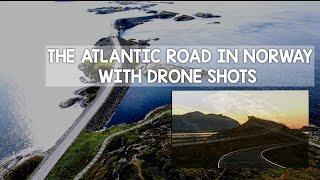
ATLANIC OCEAN ROAD DURING SUMMER WITH AERIAL VIEW (ATLANTERHAVSVEIEN)
#Atlanticoceanroad
#Atlanterhavsveien #atlanterhavsvegen
The Atlantic Ocean Road or the Atlantic Road (Norwegian: Atlanterhavsvegen / Atlanterhavsveien) is an 8.3-kilometer (5.2 mi) long section of County Road 64 that runs through an archipelago in Hustadvika and Averøy municipalities in Møre og Romsdal county, Norway. It passes by Hustadvika, an unsheltered part of the Norwegian Sea, connecting the island of Averøy with the mainland and Romsdalshalvøya peninsula. It runs between the villages of Kårvåg in Averøy and Vevang in Hustadvika. It is built on several small islands and skerries, which are connected by several causeways, viaducts and eight bridges—the most prominent being Storseisundet Bridge.
The road is a 8.274-kilometer (5.141 mi) long section of County Road 64 that connects the island and municipality of Averøy with the mainland at Eide. The road runs across an archipelago of partially inhabited islands and skerries.[2] To the north lies Hustadvika, an unsheltered section of the Norwegian Sea, to the south Lauvøyfjorden.[3] The road has a width of 6.5 meters (21 ft) and a maximum gradient of eight percent.[4] It consists of eight bridges and four resting places and viewpoints. Several tourist sites, including dining, fishing and scuba diving resorts, have been established on the islands.[5] Along with the section from Vevang to Bud, the road has been designated one of 18 National Tourist Routes.The road is a 8.274-kilometer (5.141 mi) long section of County Road 64 that connects the island and municipality of Averøy with the mainland at Eide. The road runs across an archipelago of partially inhabited islands and skerries.[2] To the north lies Hustadvika, an unsheltered section of the Norwegian Sea, to the south Lauvøyfjorden.[3] The road has a width of 6.5 meters (21 ft) and a maximum gradient of eight percent.[4] It consists of eight bridges and four resting places and viewpoints. Several tourist sites, including dining, fishing and scuba diving resorts, have been established on the islands.[5] Along with the section from Vevang to Bud, the road has been designated one of 18 National Tourist Routes
The road begins at Utheim on Averøy, close to the village of Kårvåg. It runs onto the island of Kuholmen and then across the 115-meter (377 ft) long Little Lauvøysund Bridge onto the island of Lille Lauvøy. It continues across the 52-meter (171 ft) long Store Lauvholmen Bridge onto Store Lauvøy. Next it crosses the equally long Geitøysund Bridge to Geitøya, which features a viewpoint and parking. It then runs across Eldhusøya and Lyngholmen, before reaching Ildhusøya, where there are a resting place, parking and a viewpoint. Next is Storseisundet Bridge, a cantilever bridge 260 meters (850 ft) long. The municipal boundary between Eide and Averøy runs under the bridge. It then runs across Flatskjæret, where there is a viewpoint, before crossing onto Hulvågen via the three Hulvågen Bridges, which combined are 293-meter (961 ft) long. From there the road runs through Skarvøy and Strømsholmen, both with a resting place. The route reaches the mainland over the 119-meter (390 ft) long Vevangstraumen Bridge.
Construction cost NOK 122 million and was financed 25 percent by debt to be recollected through tolls, 25 percent by job creation funds and 50 percent by ordinary state road grantsm
Wikipidia: https://en.m.wikipedia.org/wiki/Atlantic_Ocean_Road
https://www.google.com/url?sa=t&source=web&rct=j&url=https://www.fjordnorway.com/top-attractions/the-atlantic-road&ved=2ahUKEwikzt2-hsnsAhVF-yoKHU4YB-wQFjALegQIBRAB&usg=AOvVaw3Zx6WtyhrB2Dfr7ImbXZ7P
#jamesbond movie
Use in #notimetodie movie.
Тэги:
#Jame_bond #no_time_to_die_movieКомментарии:
Uzbekistan: Ferghana Valley
SLJames
11 часов расслабляющей музыки для сна, снятия стресса, от бессонницы, успокаивающая , для релакса.
Надежда Лоскутова BFMrelax
Amirul islam waz
Sultan Alam
캐나다보딩스쿨 캐나다유학 웰컴투캐나다유학원의 토론토 보딩스쿨기숙사2호점 www.웰컴투캐나다.com
웰컴투캐나다유학원 중고등학교팀
Rhonda Byrne on Everything Is Possible | RHONDA SHORT TALKS
The Secret by Rhonda Byrne


