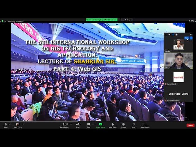
International GIS Workshop, China. Part 4: Web GIS | Shahriar Sir | GIS Speaker | Types of GIS |
🗺️ To Enroll in our GIS Courses or Training with up to 95% Discount, Visit Our Website:
https://www.shahriargis.school/courses/
__________________________________
Speech of Shahriar Sir at:
"5th International Workshop on GIS Technology and Application, China. Date: 12th February 2022."
This International Webinar was Organized by SuperMap Software Co., Ltd., China.
Guidance: Chinese Society for Geodesy Photogrammetry & Cartography (CSGPC).
Co-Sponsors: International Federation of Surveyors (FIG).
In this International GIS Workshop, Shahriar Sir as International GIS Speaker gives some valuable Guidelines to the Participants on How GIS is being used in the MULTIDISCIPLINARY WORLD including:
Civil Engineering, Architecture, Computer Science, Agriculture, Urban Planning, Environmental Science, Geography, Banking Sectors, Tyeps of GIS, What is Desktop GIS and Web GIS, and many more...
------------------------------------------------
🔶 Visit Our Website: https://shahriargis.school/courses/
🔶 Facebook: https://web.facebook.com/Shahriargisrs
🔶 LinkedIn: https://www.linkedin.com/company/shariar-gis
------------------------------------------------
🔶 Our Course List:
1. ArcPy for ArcMap Level 1: Python Programming for ArcGIS
2. ArcPy for ArcMap Level 2: 50 Scripts of ArcPy for GIS Work
3. Basic of Desktop GIS & Web GIS: All Types of GIS Software
4. ArcGIS Level 1: GIS & ArcMap, ArcCatalog, ArcGlobe, ArcScene
5. ArcGIS Level 2: Advanced Analysis, Editing and Mapping
6. ArcGIS Pro Level 1: ArcGIS Pro for Smart GIS
7. QGIS Level 1: Fundamental of QGIS For Smart GIS Work
8. QGIS Level 2: Advanced Editing, Styling, Diagram & Layout
9. SuperMap iDesktop 10i Level 1: SuperMap for Smart GIS Work
10. Fundamental of Web GIS: All Types of Web GIS Interfaces
11. GeoServer Level 1: Web GIS & Server Management
12. ArcGIS Online Level 1: Smart Web GIS Project Creation
13. OpenStreetMap: QGIS with OSM Plugin, OSM Map Download & Edit
14. Freelancing with GIS Level 1: Earn from Home
15. ArcGIS vs ArcGIS Pro Level 1: Fundamental
16. ArcGIS vs ArcGIS Pro Level 2: Map Styling, Editing & Web GIS
17. ArcGIS Pro vs QGIS Level 1: Fundamental
18. ArcGIS Pro vs QGIS Level 2: Map Editing, Database & Web GIS
19. ArcGIS Pro vs QGIS Level 3: Advanced Map Styling & 2.5D Map
----------------------------------------------------
You can easily find all of our GIS and WebGIS courses and Training here: https://shahriargis.school/courses/
📣 92-95% off for each course.
----------------------------------------------
Why Our Learners Love Us?!
BECAUSE, FROM OUR EACH COURSE THEY ARE GETTING:
§ 50 Lectures 📚
§ International Certificate of UDEMY 📜
§ Lifetime Access in the Course
§ Cheap Course with in Detail Lectures
§ Online Course, Learn From Anywhere at Anytime
§ Quiz Test 📒
§ Final Project 🗺️
§ Downloadable Resource Files for Practical Task
§ Articles
---------------------------------------------------
Contact Us:
Website : www.shahriargis.school
Mail : [email protected]
Phone : +8801714130159
Facebook: https://web.facebook.com/Shahriargisrs
Linkedin: https://www.linkedin.com/company/shariar-gis/
Learn GIS From Anywhere at Anytime!
© Shahriar GIS School
----------------------------------------
🎉( **As this is Online course, so you can Attend any lecture at anytime from anywhere, you have full freedom of these...)🎉
_______________________________________________________________
Тэги:
#gis #workshop #gis_workshop #gis_conference #international_conference #speaker #best_speaker #best_gis_teacher #best_gis_speaker #shahriar #shahriar_sir #gis_teacher #shahriar_sir_gis_speaker #gis_webinar #webinar #shahriar_gis_school #gis_in_geography #gis_guideline #gis_career #motivational_speech #how_to_learn_gis #use_gis #gis_speaker #international_speaker #gis_speech #best_gis_speech #gis_china #speech #desktop_gis #types_of_gis #gis_india #gis_usa #Web_GIS #GIS_BDКомментарии:
BEST TIME TO SAIL CROATIA
45 Degrees Sailing
Windows 11 Touchscreen Gestures (2024)
Aldo James
Face Yoga Total Face Workout for Daily Lift and Tone - Everyday Beauty in Less Time
Elemental Face Yoga with Polina
ولاگ درگذشت عمه جان ما ( تسلیت )
Komail Hamgam vlogs
Mera Dhol kuen me latke se #song #music #love #dance #ansh desi chhora
ansh deshi chhora
10 FASTEST Pontiac Muscle Cars EVER Made!
American Legends


![Fortnite EP164 [And Other Games] Playing With Viewers #INCArmy - LIVE STREAM Fortnite EP164 [And Other Games] Playing With Viewers #INCArmy - LIVE STREAM](https://hdtube.cc/img/upload/NHo2WGE5YmFaeXo.jpg)


