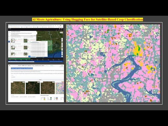
AI Meets Agriculture: Using Hugging Face for Satellite-Based Crop Classification
Hey everyone, welcome back to Space Remote Sensing and GIS! Today, we're diving into an exciting AI tool: Prithvi AI, developed by IBM and NASA. This cutting-edge temporal Vision Transformer model is trained on Harmonized Landsat Sentinel-2 (HLS) data over the continental US, fine-tuned for multi-temporal crop and land-use classification, making it perfect for agricultural analysis. I used HLS Sentinel-2 MSI Surface Reflectance data (v2.0) across 18 bands and three time-steps, which allowed Prithvi AI to analyze seasonal changes effectively. I downloaded and stacked the imagery from three different dates using ArcGIS Pro, which even generated false-color composites (FCC) automatically, helping to highlight vegetation. Once my GeoTIFFs were ready, I ran Prithvi AI to classify crops, and the model did an impressive job! Although it’s trained for US-based crops, it still picked up on familiar regional structures like rivers and classified our rice fields as alfalfa, probably due to their similar spectral properties. This has been an incredible learning experience, showcasing how AI can bring new insights into agricultural analysis across regions. Let me know in the comments how you see AI transforming agriculture! And don't forget to hit like, subscribe, and stay tuned for more on AI, remote sensing, and GIS. See you next time! 🌍🚜
#RemoteSensing #AI #CropClassification #GIS #HLSData #ArcGISPro #PrithviAI #Agriculture #MultiTemporalData
#RemoteSensing #AI #CropClassification #GIS #HLSData #ArcGISPro #PrithviAI #Agriculture #MultiTemporalData
Тэги:
#space_remote_sensing_and_GIS #ArcGIS_Pro #GIS #Remote_sensing #space #AI #CropClassification #Phenology_analysis #HLSData #PrithviAI #Agriculture #MultiTemporalDataКомментарии:
AI Meets Agriculture: Using Hugging Face for Satellite-Based Crop Classification
Space, Remote sensing and GIS
Buses Stuck | Calgary Snow - November 18, 2024
My Journey Canada
Amazing technique make DIY piggy bank without pottery wheel || money saver mini clay bank
Creative Ideas by Shefu
Rieker L3277 Nikita 77 SKU:8735841
Shop Zappos
5. Complete Flutter Course - Module 3 (Part 1): Understanding State Management in Flutter
The Flutter Fairy (Coding and App development)
MAURICIO POCHETTINO BEST GOALS AND SKILLS
Football Land


