RiskMeter Parcel Level Geocoding- PART 2 of 2
Parcel Level Geocoding
In the real-estate industry it's all about location, location, location. This holds true when it comes to underwriting as well. CDS is proud to
announce that we have added a parcel level geocoding database to the RiskMeter Online. This new feature will immediately help insurers when assessing natural hazard risks.
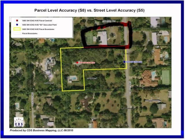
Although standard geocoding is reasonably accurate, parcel level geocoding takes it one step further. When an address is run through this database, it will place the address entered into the center of the parcel. This is more accurate than street level geocoding, which uses street segment interpolation.
Uses of Parcel Level Geocoding in Underwriting
The main benefits of parcel level geocoding will be in areas where accuracy is vital. Storm Surge and Flood reports are two good examples where the difference of just 100 feet can yield substantially different results.
For example, leveraging parcel level geocoding in conjunction with our Flood Elevation and Storm Surge reports can provide more insight into how much risk a parcel of land is exposed to. This information can be used to accurately price policies and in some instances provide your company with low risk business other insurers won't touch!
Another example of Parcel Level Geocoding would be assigning the correct premium tax codes to policies. In certain states, municipalities, counties
and fire districts they have set up premium taxes that must be collected and reported by insurers. Most of time these districts are parcel specific.
By leveraging our parcel level geocoding, insurers can quickly and accurately assign tax codes, while avoiding expensive penalties.
Questions?
For more information, please contact Daniel Munson, Founder, RiskMeter at 617.737.4444 or [email protected]
Тэги:
#Featured #Webex #Parcel #Level #Geocoding #20101118 #1901 #12Комментарии:
150314 EXO’luXion_baby don't cry kai focus
Kai Ballerino
Japan Land of the rising sun # 1 by Barb & Ernie's Film production
Barb & Ernie Kitchen
ALLELUJA - WIELKANOC 2014 - WIĘCBORK
przemuce
Top 10 Unknown Facts In Telugu | Interesting Facts In Telugu | Telugu Ammayi
Telugu Ammayi - Interesting Facts in Telugu
Bholya - Dil Kithy Khrayae - Imran talib Dard - 2022 - Waseem Cassette House
Waseem Cassette House
POIN DUA EKOR KACER BORNEO
Rimba Piomunt Channel
رو مخ و اعصاب ترین چیزای رد دد !
Hamin Skarfin


