Adirondacks New York Wilderness Region 1895 Stoddard rare pocket map | Brian DiMambro Virtual Tour
Available At: https://briandimambro.com/collections/video-collections/products/adirondacks-wilderness-region-new-york-c-1910-stoddard-large-pocket-map?variant=39523191685198
Short video captures condition much better than photos. Please watch prior to purchase to ensure a full understanding of the set.
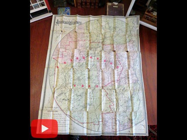
Map of the Adirondack Wilderness.
Published 1895, Glens Falls, New York by S.R. Stoddard.[ Eighteenth revised edition].
Lithographed folding map. Text in English. Lake Champlain is along the tip right side, interesting assortment of details including hotels, fishing info, ferry prices, etc.
Publisher's cloth folding covers binding, embossed title lettering. Old library rubber stamps on blank back of map (withdrawn stamp), these stamps are not visible when viewing the map face.
Large folding pocket map is over 125 years old and shows some clear signs of handling and time.
Binding gently age worn, remains overall sound and attractive as an object.
Map paper is gently toned, numerous fold lines splits and intersection separations with a few spots of small paper loss, still a nice looking example.
Still attractive on the shelf. Map displays a pleasing and unique age patina, the age flaws easy to overlook or forgive.
Please review photos for more detail showing how this scarce 19th century Adirondack N.Y. pocket map survives. The asking price reflects the condition based on our examination and 35+ years full time exposure to antiquarian maps and books. Flaws seen and described have been taken into account.
Book Measures c. 5 3/4" H x 4 1/4" W.
[B3603].
Комментарии:
Adirondacks New York Wilderness Region 1895 Stoddard rare pocket map | Brian DiMambro Virtual Tour
Brian DiMambro — Rare Books & Antique Maps
Suriye Alevileri: Lazkiye'de HTŞ nasıl karşılandı?
BBC News Türkçe
Paint The Town Red - Doja Cat TikTok Dance Challenge Compilation
The Best TikTok Compilations
sa27 fe r7lt el7yah / سائح فى رحلة الحياة ( فيلم السائح ) بافلى فون
Bavly Phone Channel
Step By Step Glossy "Winter" Makeup Tutorial For Beginner using NEW & Affordable Products #makeup
My Hotchocolate [Preeti Shah]
LIVE | ONLINE CLASS | 6TH TAMIL | NEW BOOK | SANTHOSH IAS ACADEMY - ARCOT
SANTHOSH IAS ACADEMY
MOV Video Repair: Fix Corrupted MOV Files | Working Solutions | Rescue Digital Media
Rescue Digital Media
Scythian Biocomposite Bow by Grozer - Review
Armin Hirmer

![-[]-Soft ideas oc for boys and girls-[]-//gacha life//-{By choco zavrik}- -[]-Soft ideas oc for boys and girls-[]-//gacha life//-{By choco zavrik}-](https://hdtube.cc/img/upload/d1Y5QlJTR1VTamw.jpg)


