DO No watch, No share: THE BRUTE POWER of E-cognition segmentation on Landsat8
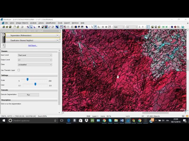
The raw use of multi-resolution segmentation on a GEOTIF made of 3 Landsat 8 bands (543). 27464 polygons.
Scale 60 (texture) color 0.5.........the resulting vector could be used as starting point to produce a land cover map. The smallest polygons are around 2 hectares, the biggest is 1000 hectares of forest...SOON we will see how to make a FOREST - NO FOREST MAP QUICKLY...... TEST VIDEO by E-mi S
Scale 60 (texture) color 0.5.........the resulting vector could be used as starting point to produce a land cover map. The smallest polygons are around 2 hectares, the biggest is 1000 hectares of forest...SOON we will see how to make a FOREST - NO FOREST MAP QUICKLY...... TEST VIDEO by E-mi S
Тэги:
#e-cognition #multi-resolution_segmentation #segmentation #Land_Cover #Land_Use #Forset_cover #Camboida #E-mi_SКомментарии:
DO No watch, No share: THE BRUTE POWER of E-cognition segmentation on Landsat8
E-mi 17 e. stephanenko
Evolution of Super Sonic (1991-2022)
ProsafiaGaming
10 Min Morning Yoga to FEEL INCREDIBLE!
Yoga With Bird
Arvind Krishna, IBM | Red Hat Summit 2019
SiliconANGLE theCUBE
NEW VW Transporter T7 Unveiled - Thoughts and Opinions
Staycation Lifestyle
Camping | Bald Eagle State Forest PA, Nov 2023 | @GFC Go Fast Camper
Out Of Office Camping


